Hurricane Melissa heads towards Canada
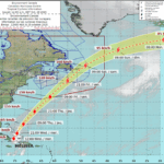
Hurricane Melissa is tracking to reach Newfoundland’s Avalon Peninsula by Saturday morning, the Canadian Hurricane Centre (CHC) reports in a statement Wednesday.
“The wind circulation of Melissa is expected to track offshore of Newfoundland, but recent weather model trends suggest it may track closer to Newfoundland (island portion) than expected earlier,” CHC reported early Wednesday morning. “Some models predict the centre — of what will likely be post-tropical Melissa by early Saturday — tracking very close to or even over the Avalon Peninsula…”
The U.S. National Hurricane Center’s (NHC) forecast cone has wind gusts of about 110 km/h hitting the Avalon Peninsula, which includes the provincial capital city of St. John’s, early Saturday morning.
Remnants of Hurricane Melissa could bring wind gusts greater than 100 km/h to the Avalon Peninsula and contribute to between 30 mm and more than 50 mm of rain in the Maritimes, Ontario and Quebec, The Weather Network (TWN) reports.
Parts of Ontario and Quebec could see winds strengthen to 50 to 70 km/h Friday evening as the storm system moves out of the region, TWN says in a statement.
The most powerful Atlantic Hurricane in 2025, Hurricane Melissa made landfall as a historic Category 5 hurricane in Jamaica on Tuesday, followed by a second landfall in eastern Cuba on Wednesday morning.
In Canada, TWN is forecasting widespread totals of 30-50+ mm of rain across the Maritimes on Friday, with Halifax seeing the heaviest rain by Friday afternoon. Rainfall will persist into the evening in eastern regions of the Maritimes.
“Winds may strengthen, reaching 50-70+ km/h in many areas on Friday,” TWN says in a release Wednesday. “By Friday night into Saturday morning, Melissa’s weakening could expand its wind field, increasing the potential for gusty winds to impact Newfoundland.”
TWN reports moisture streaming up the Atlantic coast may bring heavy rain to parts of Ontario and Quebec starting Thursday. “While this rain isn’t directly caused by Melissa, the hurricane is helping to channel additional moisture into the region.”
A low-pressure system tracking south of the border is set to bring rainy and windy conditions to southern Ontario as it pulls in tropical moisture from Hurricane Melissa off the Atlantic coast.
Rain is expected to begin Thursday morning, affecting areas in Ontario from Hamilton and Niagara to Toronto and Kingston. By Thursday afternoon, heavier rain is likely in eastern regions, including Kingston and Ottawa.
Rain will ease throughout Friday for the Greater Toronto Area and Niagara, with conditions likely drying out in time for Halloween activities Friday evening, TWN says.
Navigating the Future of Insurance: Risk Management Trends, Challenges and Opportunities
By
Sponsor ImageRainfall amounts of between 20 mm and 30 mm are expected across much of southern Ontario by Friday, with higher totals of between 30 mm and more than 50 mm possible for areas like Kingston, Ottawa, and Montreal.
As the system moves out the region, winds could strengthen to between 50 and 70 km/h.
“It will be a wet and windy Halloween and start to the weekend for many, and for the most part, all that weather will NOT be from the hurricane,” says CHC’s statement.