Erin to brush past Atlantic Canada, with forecasted risks of waves and wind
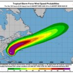
Hurricane Erin, now downgraded to a Category 2 storm (sustained winds of 154 to 177 km/h), is tracking to brush past Newfoundland and Labrador as a tropical storm this weekend, generating coastal ocean swells and projected “storm to near hurricane-force winds,” says the Canadian Hurricane Centre.
“Given the large size of Erin, it is likely to bring heavy wave activity to Eastern Canadian waters and also to the south-facing Atlantic coastlines of Nova Scotia and Newfoundland Friday/Saturday,” the Canadian Hurricane Centre says.
“At this stage, we don’t expect the storm to impact land other than the ocean swell, which will likely create hazardous surf conditions including rip currents — of particular risk along the Atlantic Coast of Nova Scotia Friday.
“Offshore districts that should pay particular attention: George’s Bank, the Scotian Slope, Laurentian Fan and the Southern Grand Banks. Storm-force winds are possible over southern portions of these forecast zones.”
Glenn McGillivray, managing director of the Institute for Catastrophic Loss Reduction, told Canadian Underwriter last week that Erin has the potential either to help or hinder firefighting efforts against wildfires in the province.
“On one hand, if the storm brings soaking rains, it could help the fire situation,” he said in an statement published Aug. 13. “If it doesn’t bring much rain but ramps up the wind, it could be detrimental.”
He made his remarks early in the formation of Hurricane Erin, when its precise path was still unknown. In a recent statement, the Canadian Hurricane Centre said there was no rain projected as a result of Erin.
Also in the news: Hail Alley: Why repeated hail damage is so concerning for insurers
Canadian adjusters have been on standby to gain access into areas hard hit by out-of-control wildfires.
Newfoundland and Labrador Premier John Hogan reported yesterday an estimated 203 structures have been destroyed by the out-of-control Kingston fire burning in Conception Bay North. He noted these structures are not all homes, with the estimate being based on structures that lost power, including sheds, commercial structures, and an elementary school.
As of Aug. 13, roughly 20,000 residents around Newfoundland and Labrador’s capital city of St. John’s had been evacuated due to out-of-control wildfires. Rain and cooler temperatures have helped firefighters prevent further growth of the Kingston, Paddy’s Pond and Martin wildfires.
As of yesterday, the only areas in the province considered to be at an extreme risk of fire are portions of the Bonavista Peninsula as well as the Trinity Bay area, per CBC News. The southwest corner of Newfoundland is still at high or extreme risk, and that is the area where National Hurricane Center wind maps show Erin’s winds may blow through.
Hurricane Erin is the first major hurricane of the season. Erin intensified into a Category 5 storm last weekend (wind speeds up to 260 km/h on Saturday), making the fastest-intensifying storm on record, CNN Weather reported.